To look at a map of No Zona is to peer into the depths of the hopes and dreams of every rancher whoever set eyes on this strip of land and thought, yeah, I could make a go of this. It is a map dotted with springs, water holes, tanks, tubs, streams and even canyons with names that would denote the existence of water. Yet, the first thing anyone will tell you of No Zona is that there is no water.
Both are equally true.
No Zona exists as a precursor to one of the most difficult places to travel in the west, if not the world. A place defined by the mighty Colorado and all of the world seems to drain into its depths dragging the sediment out of washes, through draws, down into gulches and eventually roaring through canyons with vertical walls rivaling any man-made structure. To say water is non-existant is to misunderstand the essence of the landscape.
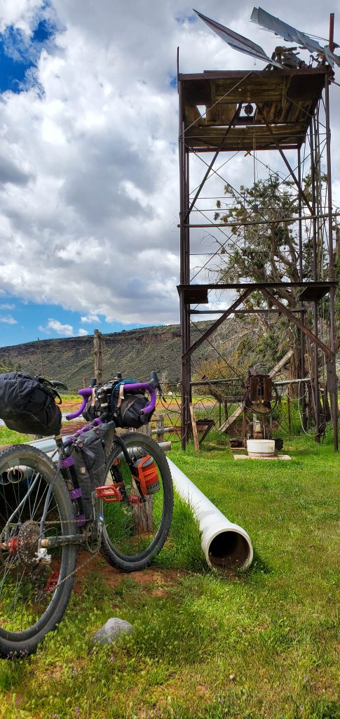
And the flip side is that map. A guide to treasure where the X is replaced by blue dots. The evidence that water does exist is everywhere. Even at those blue dots it is clear that the hopes and dreams of some rancher were at least, at one point, based on reality. There was water, it’s just no longer there. Empty tanks, water lines, windmills and cow ponds, all of which have traded in their treasure for one thing this place has in spades, dust.
To travel through this place, one must compromise. The easy way is to go quick. Hop on the moto and travel through it at a speed that allows you to carry little and stay for a short time. The other, more difficult choice, is to carry what you need, slow down, find water and be fully immersed in the vastness of its contours. For us, there is only one choice. Grab the treasure map, get as much beta as possible and experience the land the way it has been for 100s of years, slowly.
Steep – Day 1
Put your nose to your shin or, I guess in this case, to your front tire. I feel like I’ve been staring at that 2″ patch of rubber slowly moving forward for the past several hours. That feeling is mostly caused by the fact that I have been looking at that patch for the past several hours. The climb is steep. We are loaded with the gear we need for the next three days weighing down the bikes and the feels say we are barely moving.
I thrust my right leg down while yanking on the handlebars, the forward momentum lurches me forward and then pauses. I repeat the motion with my left leg to keep my bike upright and slowly moving up the hill. I’ve been in this endless cycle for a few hours. My lower right back has consistently been getting tighter and tighter and every yank on the bars, I feel it going deep above my hip. I can see the top of this climb and all I can assume is that we are once again at a false summit. False Summit #312…ish.
When Lynda sent me the Strava links, all I could do was get excited. In the immortal words of Jaffar from Aladdin, I was “ecstatic.” It wasn’t until hour 3 or 4 that I thought to myself, “Moose, you know it’s a bad idea to follow a route that Dave and Lynda put down to go spring hunting. You know it won’t be the fastest nor easiest way to the top. And yet here you are.”
Leg thrust down.
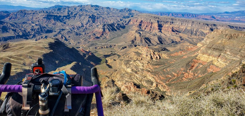
And for some reason, a snide smile has been permanently glued to my face. Every time I turn around to look back where we have come from, I see the layers that define STG being treated to a view of Pine Valley Mountain that is actually complete. Seeing past the Cottonwood Wilderness and its red cliffs, the Roadless Inventory Area and into the Pine Valley Wilderness area as the cliffs break and leap toward Signal and Burger Peak. The snow is accented nicely by the green and red surrounding it. Every time I stop staring at that 2″ patch of tire, I take a few moments to turn around and enjoy the landscape that has completely unfolded behind me.
When we left from our back door in downtown St. George, it was warm. T-shirt and short weather by anyone’s estimation. Now, hours later, the cactus has been replaced by Juniper and Pinyon’s that then subbed out for Ponderosa Pines, and it’s cold. We have continuously added layers as we climbed from the desert floor. They say that you have overpacked if you don’t wear everything you packed at some point, well, we didn’t overpack. Every layer is engaged and we are still freezing.
My biggest concern heading out was finding water. I enjoy warm meals and early morning coffee so I can sip on something hot and watch the sunrise over the horizon. As we peak out, there is water everywhere. It clearly rained the night prior leaving puddles, washes with streams flowing and giant ponds where normally there would be dust and sage brush sprouts. Water wasn’t a problem at this point. Knowing that Mama Bear was not feeling well and being able to deduce that she was getting to her limits, I suggested we make camp.
Nah, we are dropping off the other side so it’s warmer.
Nuf said. We knew there was water at Cougar Springs and that was our original destination for the day. We finally hit the top of the elevation profile and drop. The descent matching the grades of our climb and throwing a bunch of loose basalt baby heads to make it, you know, interesting.
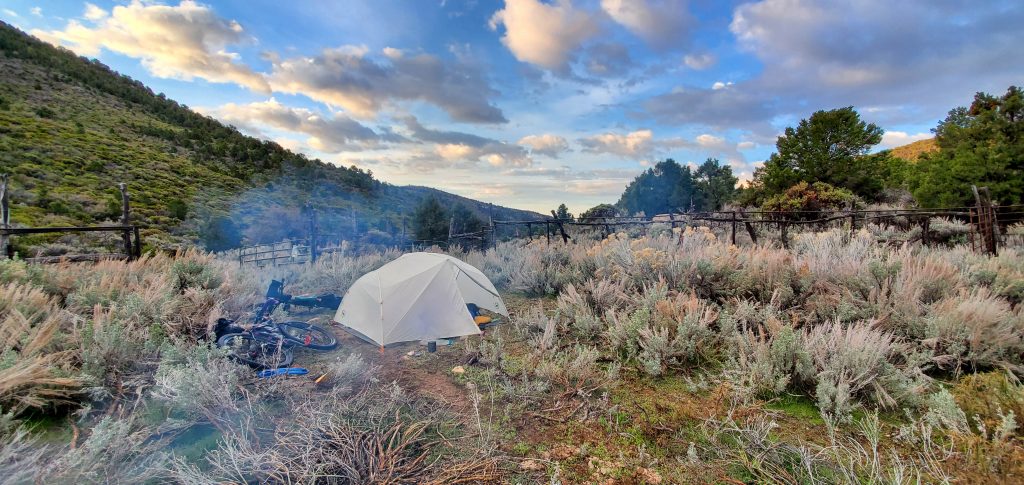
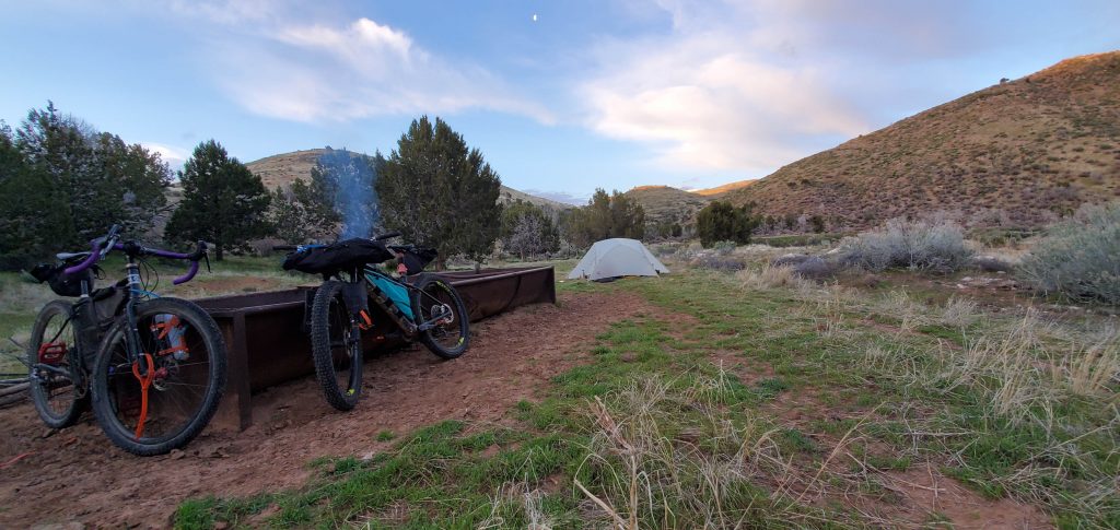
We pull into the springs, a cement tank and trough filled with alge, pretty much as twilight fades into evening. Knowing that our bones are cold, I immediately begin gathering wood for a ninja fire. Mama Bear starts to set up the tent. Then water. Then bed. It was a long and satisfying day. And we’re both stoked to repeat it for the next 2 days.
No Zona
The Arizona Strip is an anomaly. In the compromise of 1850, the border between Utah and New Mexico was settled. It had nothing to do with geography and everything to do with slavery. It put the southern border of the Mormon state 100ish miles north of the Grand Canyon. This essentially cleaved the North Rim politically from anything that actually surrounded it. The Strip, or No Zona as we like to call it, is the land squeezed between the Grand Canyon and the southern border of Utah. Isolated from the rest of Arizona by geography and left out in the cold by the politically drawn line, it is a no man’s land.
Mostly managed by the BLM, there isn’t much traffic. There are still cows grazing on the meadows and wagon trains have been replaced by the OHV crowd. Otherwise, this land is essentially the way it has been since Powel came through and documented it in the late 1800s. The biggest difference is that the whole thing has now been mapped and two track stretches over it.
Rough – Day 2
The bags attached to the rigid bike I am riding are shaking violently.
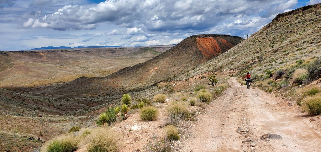
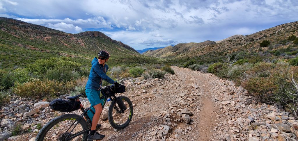
Today the elevation profile was more or less flat with a little bit of down and a little bit of up. We planned on making better time than the uber steep constant climb we did the day before but the map didn’t show all the rocks we would have to maneuver. The roads we are following take us through a layer of basalt rock.
If you’ve never experienced roads through basalt, there is no way to make a smooth one. You can grade it, but every layer of rock you pull off the top is sitting on more rock. The most logical way to try and construct a road is to build up soil, brought in from elsewhere to cover the rock. This works great until the rains decide they like the rock better and redesign your roads for you. When you pass through basalt, it will be rocky.
Bouncing along the roads is somewhat like being stuck in bumper to bumper traffic. The side of the two track I am riding always seems to be the bumpiest. I make the effort to get through the even rockier median dividing the two tracks only to find that it is now much bumpier than it looked and on par if not worse than where I came. It’s pretty much the same game as switching lanes in traffic. As soon as you do, that lane completely stops moving. Every time.
While our going is slow, we take advantage of the opportunity to view the flora. We have descended into Joshua Trees, Cholla, Yucca and they are all accented with the blooms of the desert. Indian Paint Brush, Globe Mallow and the almost to pop cacti blooms keep us smiling and pointing to each other as we are jostled along our way.
One of the maybes of this trip was the possibility of catching some petroglyphs. This possibility kept me looking for a Nutter’s Twist on the map. A place my pops had described to a tee and where he had found a panel of ancient art. Thing was, nowhere on our map was this called out as Nutter’s Twist. Of course, the moment I give up, we climb said feature stopping at the top for a view of the canyon we just came out of and for the first time the Garmin shows the road clearly denoted as, well, you guessed it, Nutter’s Twist.
With storm clouds gathering around us, a few drops of precipitation fall and we start thinking seriously about camp. We need to find a spring to refill water and then it’s anyone’s choice. Leaving the sandstone formations of Hidden Canyon we turn and head up Jump Canyon toward our spring. The beta provided was that it was a beautiful spring in a sandstone alcove, but it did take some getting to.
We mash the pedals getting as high as possible up the old, abandoned jeep trail. When it turns and the pitch gets unridable, we stop. It’s time for dinner and we pull out the stove and use our remaining water to cook having faith that our beta is accurate and the stream, still up-canyon a bit, is flowing.
We strap all the water containers we have and the filter to my back and continue upward toward the spring. The jeep track narrows, is covered by rock falls, gets pretty damn steep and eventually enters a narrowing sandstone canyon. After a half mile or so of hoofin’ it, I hear water running to my right. We wander around trying to find the best way to get to this water. I pose for the game cam. We check out the cat tracks that are everywhere. And we fill our bottles.
And then descend back to the bikes with 8 liters of water. Last objective of the day, find camp.
Windy – Day 3
An empty Coke bottle goes ripping by headed due south. The ripping headwind propels it past us inspiring a chuckle. There are times when conditions are just what they are. You’re stuck in them and the only way home is through ’em. This is one of those situations. We’re within a mile of our house and our forward momentum has slowed to almost-tipping-over pace. I chuckle because it’s the only response that makes any sense.
But we’re getting a bit ahead of ourselves.
The sound of rain on the tent was heard most of the night. We woke up to a soaking wet rainfly, damp grass all around us and stuck in a canyon that was impeding the sun from helping us much at all. And despite the dampness, the green and warm hues coming from the impending sunrise were enough to fill a thousand souls with joy.
After our typical coffee in bed, we pack up our wet gear and get ready for what we hope will be an easy day back home. We already got the majority of our climbing done on day 1. We know there will be a bit more, specifically coming up Ide Valley to the spring. But we also know what the road conditions are like and the elevation once we get out past Tombstone. We are both very much looking forward to dropping down the Quail Dugway.
After pedaling for a few hours through open terrain and on roads that are much smoother than we had experienced the past two days, we hit the main drag, the road to the Dugway, the place we thought all of this would turn easy and we could more or less coast home.
Of course, as these stories go, this is when the wind really hits us. The breeze and occasional gust have turned into a crazy, straight on headwind that still has gusts just now they almost push us over. We make it to the top of the our downhill, brace ourselves and head down. The wind gust battle our forward momentum and when they become sidewinds, the ride gets rowdy to the point of discomfort.
With nothing but beer and junk food on our minds, we push forward. Slowly hitting pavement and then making our way back through town where anything and everything that is not nailed down is blowing past us at 20 mph.
Staying Home
There’s something special about riding from your front door to find adventure. Often times, you leave your door and some small thing you hadn’t seen before will strike a smile. It’s another, when you leave your house, spend three days engulfed in solitude, beauty and calm all while seeing things you hadn’t before.
And while the map of NoZona shows the hopes and dreams of old ranchers long passed away, they now strike our imagination with a similar chord. We might not be looking to make money from public lands and raise cattle with that water, but each blue dot is a place that could springboard us even farther into this forgotten place.
And that is to peer deep into our hopes and dreams.
P. L. and R.
Great write up! I especially liked the description of riding on basalt roads! I’d love to get access to the Strava info!
Thanks!
Jared
I love when you pose for my game cam
Every chance I get
It’s all here, https://www.strava.com/athletes/1324852