We awoke with the sun and to the roar of the river that we had crossed the night before. We had arrived late and thrown up camp in the dark. I’ve always enjoyed that kind of start to a trip. It gives me the feeling that everything around me is a surprise. The trees, the river, the giant peaks peaking out from the tops of those trees all surprised me with their immensity. They always seem bigger, more real when you first witness them from within. Driving up in the day time everything starts small and slowly gets bigger. By the time you are there, it feels like you’ve already seen everything.
And then I got those nerves that only come when you know that within a few hours you will be in pain. There’s no way around it. It’s going to hurt to go over that pass and then the next one and the next one. Legs will burn. Lungs will gasp for air and everything will get fuzzy, but then again, that’s how I know I’m in the mountains. I used to thing it was normal, but I guess having tunnel vision and stars swirling around your head any time you are headed up hill at elevation, is less common than I thought.
The Day’s Objectives
 Once you start walking, things go simple. There’s not a lot to worry about. Put that foot ahead of that one and then repeat. Make sure you don’t fall down, make sure you don’t fall behind. As such, our goals for the day were pretty straight forward. We had a pretty significant climb, Mono Pass, that we would need to get over. Thanks to THE PLANNER’s amazingly detailed maps, we knew the we would be at the top somewhere between 3-4 miles and a couple thousand feet of climbing.
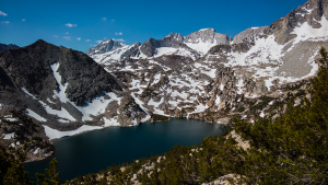
The climb to the top would take us around Trail Lake, Summit Lake and Ruby Lake. Most of these we would see from above as we climbed up the pass, they were visible all around us. We would also have Mt. Starr to our left in addition to god only knows how many other granite, snow covered peaks surrounding us. Essentially the first part of our trip was to pass through the portal of the foothills to the High Sierra.
Then Lunch at Trail Lakes.
Part 2: Descend down Mono Pass going from the dry eastern slope to the less dry western slope of the Sierra. Also, lose a ton of elevation as we drop into Mono Valley and follow Mono Creek past 4-1 Recesses. Find a camp. Sleep.
- Total mileage: 13.29 (according to the Garmin which is never spot on)
- Elevation gain: What seemed like forever or about 1800 feet.
- Elevation drop: It felt like we went down long enough to drop through all the rings of hell. Or about 2500 feet.
- Total time: From 8:28 AM till 5:36 PM or in adventurer terms, all day.
Significant Happenings
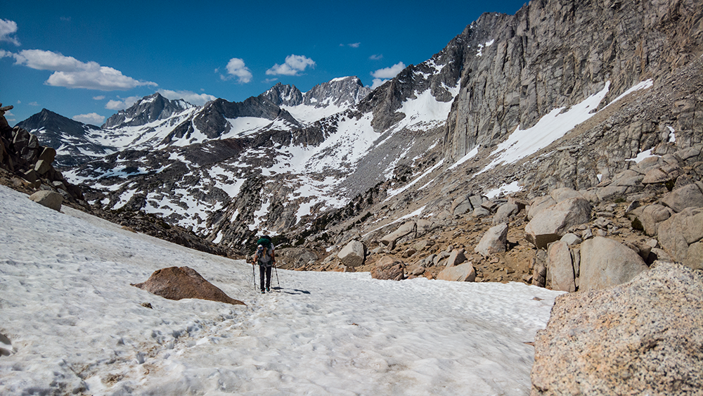
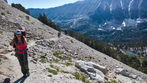 Mono Pass was brutal. Ok it wasn’t brutal unless we use 21st century exageration terms. In reality, it was outside of our comfort zone. We had to walk all the way with stuff on our back. I guess for me to say that was brutal, I would have to then invent another word to describe things like the Spanish Inquisition. The climb was pretty much right out of the gate. And by pretty much I mean we started climbing the minute we walked away from camp.
The trail to the top of the pass was mostly cut into the side of the mountain leaving us with views for days. The walk to the top, as much as it seemed to never stop, was interrupted countless times by our stops. It was hard to put one’s head down and trudge forward when there was so much beauty around us. Lakes, peaks, snowfields, you name it, we could see it.
But my favorite part was when we hit the top. Since I was a kid, I’ve had these images, these fantasies of climbing mountains. The biggest reason I wanted to climb these mountains were because of the images of two climbers tied together as they traversed a snow field with giant peaks as their only companions. I think you know the kind of photos I’m talking about. Well, we hit the snowfield. No we weren’t doing any “real” climbing, but the aesthetic was close. (Day 3 the aesthetic was dead on, but you’ll have to wait for that photo)
Lunch at Trail Lakes was pretty rad. Being a desert rat by birth, any time there’s water, I think it’s something special. Put that water in the tops of mountains and well, that’s pretty close to Nirvana. Do all of that after climbing a big mountain pass, with a little shade and time for a nap. I think you get the point.
After our nap, lunch and hammock time (for the Sticks Family and B&R), we threw our packs back on (and by threw I mean we picked them up slowly and maneuvered our bodies under their weight. There easily could have been some help from others. Ok, threw is not the right word, but whatever) and headed down into the valley.
As mentioned in the previous post, Shelby Sticks had planned out several possible campsites for each day depending on our speed. There was the minimum campsite which would make days 2-4 harder. There was the somewhere in between spot that would be nice and then the we push hard today so days 2-4 will be easier. These came up every day as we made our way around the loop. If I remember correctly, we settled somewhere in the middle right around the time that dinner seemed like a really good idea. Then we sprayed half a gallon of bug spray all over us and tried to get a fire going as quickly as possible, but not a raging fire, more of a smoke out this place to kill the bugs kind of fire. Yea, the bugs sucked.
And then we drank ourselves silly. Ok. That didn’t happen. The medication I now “get” to take when I’m at elevation requires that I don’t poison myself with alcohol. The majority of the group had decided to stand in solidarity with me and also they didn’t want to carry it. We hung around the campfire until the smoke and bugs were too much to take and we sauntered off to the bug free zone aka our tents.
The Day’s Photos


The Maps
Part 1
Part 2
P. L. and R.