A few months back, Shelby texted me to see if we wanted to join him and Ben on yet another backpacking/hobo adventure. I was all in, but KB had already booked a trip to the middle of fucking nowhere (I promise to share that story at some point) so we were out. Being human, I am especially susceptible to the power of suggestion and I don’t like missing out on adventures.
KB and I did our thing that weekend clear out in the eastern part of Utah. A place you should go once but then never return. We had a good time, but upon our return seeing the photos being posted of our missed opportunities left us jonesing for a little more of the hobo lifestyle. Luckily it was still summer and we had some time.
The Great Basin National Park is best known for it’s caves. And despite its name, happens to have some pretty high peaks. That’s what we wanted, to see tree lines disappear beneath us and watch bald peaks rise above us. We wanted to strap our homes to our backs and forget about the modern world for a couple of days. We wanted to feel the dirt beneath our boots and beneath our backs at night.
Off we went.
The plan involved us leaving SG late on Tuesday. By the time I got home from work, started to think about getting packed it was almost 8. We changed our plans and decided we would get up super early and hit the road to have most of the day to enjoy the trail. We woke up. And then something like three hours later we finally boarded the Mooseknuckler-mobile and headed north.
The road is one less traveled. You take off of I-15 and head northwest toward Nevada. If you’ve heard of the Dead Zone, this is part of it. There’s nothing but sage brush and dirt for about as far as you care to see. Then in the distance you can see mountains start to rise above the basin. That’s where we were headed.
Of course, my planning skills usually involve some of “Fuck it! We’ll figure it out when we get there.” and this was no exception. We drove right into the park only to realize that the trailhead we were looking for required us to turn off the main road a bit back. So naturally we headed to the smallest town in the world and found a liquor/café/hotel/general/can’t stand up in here store to ensure that our supplies were covered. A bottle of Jack and we were back en route.
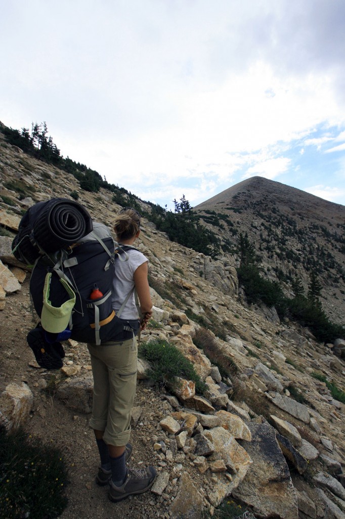
We found the trailhead at the end of a dirt road. This dirt road took us into the heart of a valley and we could see the peaks rising above us. We knew that we had a lot of climbing to cover in a short distance. The plan was to eat lunch at Johnson Lake and possibly camp there. That meant we had about 3.5 miles to go and it was all uphill.
The rhythm of keeping one foot in front of the other put me into a meditative state. My thoughts wandering and the anxiety of getting to this place started to roll off the back of my boots as we progressed. We entered a stand of trees next to the stream. I was ahead of KB. I looked up the trail and then stopped dead in my tracks. About 30 yards up the trail was a big ass mountain lion.
He proceeded to not give a shit about me, but cross the trail as I motioned to KB to hurry up so she could see it at as well. She got to see him just as he entered the trees and disappeared. KB had never seen one in the wild and it was pretty exhilarating to be that close to one. He also had some strange coloring. It was like he had been capped with chocolate. Yup, a chocolate covered kitty cat in the middle of Great Basin National Park.
Of course, KB was more than ecstatic and had to tell every single person that we saw about our cat crossing. One of the rangers was a bit pissed as he had been working in the park for 11 years and hadn’t seen one.
We trudged on. The trail got steeper and steeper, less switch backs and more of keep your head down and keep your feet moving.
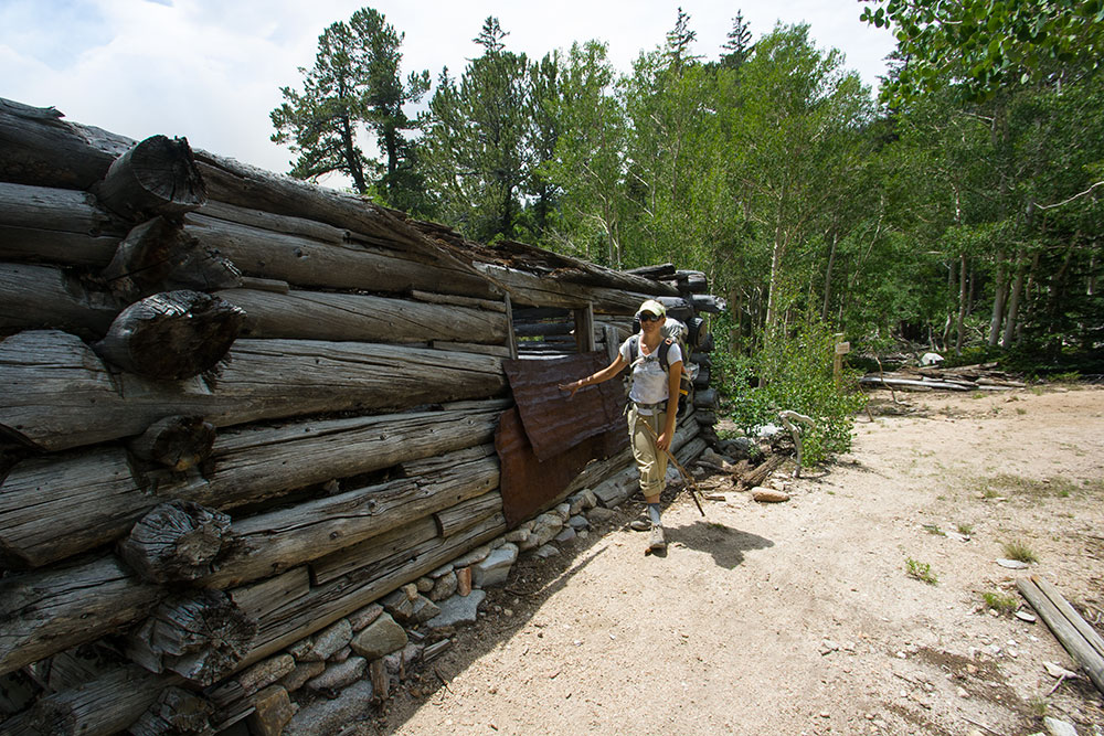
Johnson lake had been mined, I would say heavily, and as we got closer, we started to see cabins and structures that had been used to that end. Right before we got to the lake, there was a bunch of people walking around one cabin with little orange flags. After KB got done telling them about our cat sighting, they told us they were doing some archeological work. Basically taking a complete survey of the park and the historical sites within it.
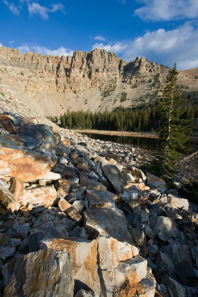
We ate lunch at the lake, refilled our water bottles and then decided to make our way over the ridge.
Which looked like this,
The trail goes behind the rocks in the middle of the photo and then follows the rock slide up and to the left. Needless to say, it wasn’t any less steep than it looks in the photo. It was a trudge that’s only saving grace was the fact that we got to look back down onto Johnson Lake the entire time.
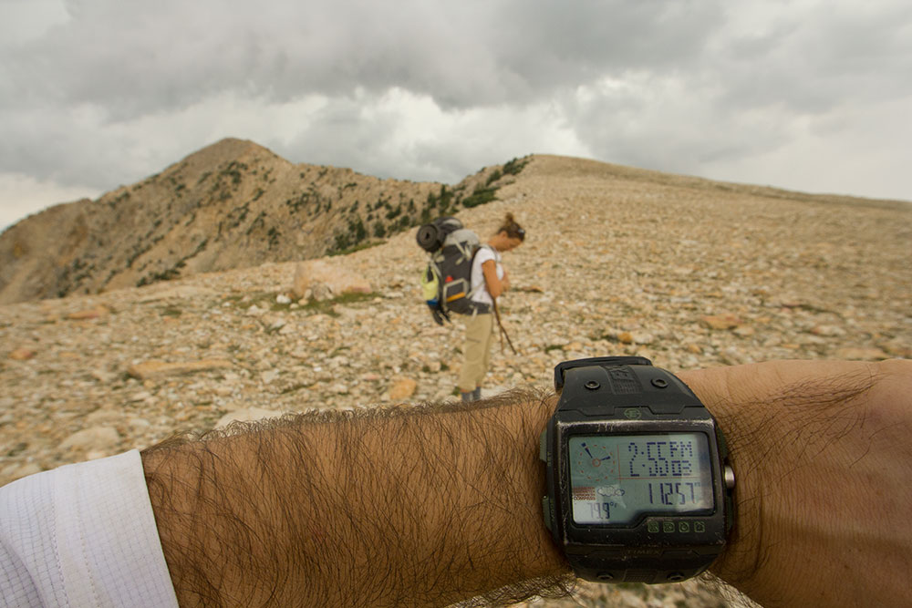
If you can see my watch, you can clearly tell that we are above 11,000 feet. As you can see, the peak in the distance is well above that. We had ambitions to climb Pyramid Peak but at this point the thunder was rolling and the lightning was striking. We promised ourselves we would make it to the top the next day. And then we headed down into the next valley.
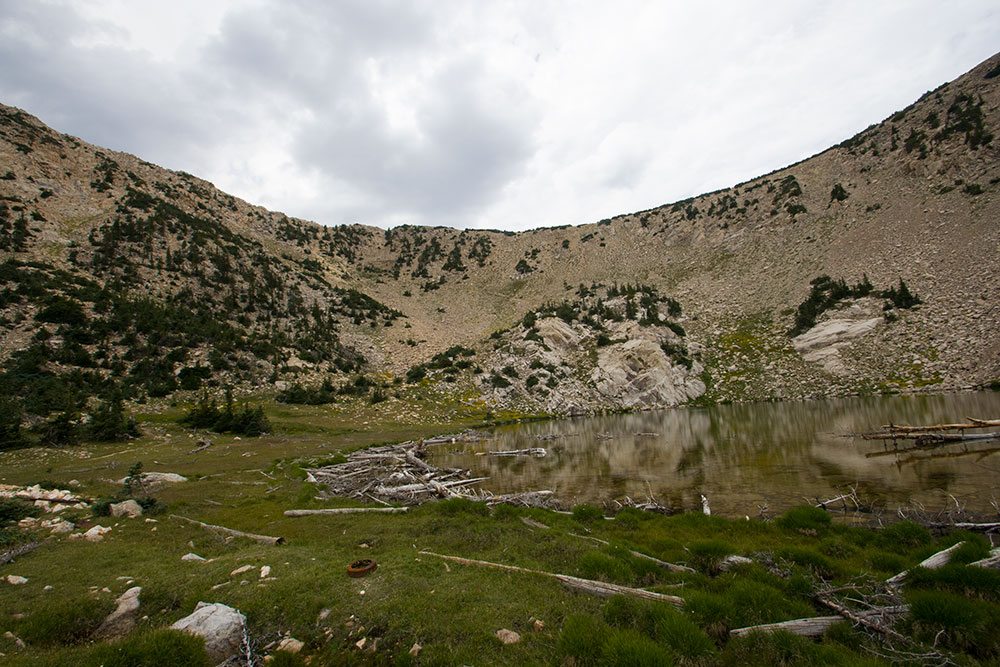
Our destination, Baker Lake, was in the valley below us. We knew that because it was pictured on the map, but we couldn’t see it. One of the fellow hobos we had passed on the way up, had described it as almost non-existent. We let gravity do some work and headed down the grade following the cairns set to mark the route (we weren’t on a trail at this point) until we kind of forgot about that and made our own trail down, following the stream. The stream does not drain into Baker Lake. We found this out as the stream dropped down the valley. We were forced to backtrack and find some cairns. Then we made our way to the lake.
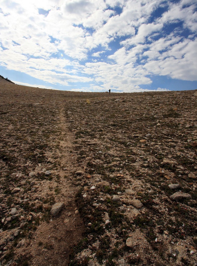
At this point we were ready to be done hiking. We came on a small pond that fit the description the guy on the trail had given us, but we couldn’t find a descent place to camp so we started to circle out looking for a flat, not rocky spot. I noticed that there were some more cairns moving away from our “lake,” we decided to follow them.
This is what we found,
Obviously, we were pleased that this was our campsite and not the less than stellar pond we had found.
The tent went up quickly, as soon as we found a flat spot to pitch it. The rain was still threatening and we were anxious to make sure we had shelter. Once we solved that problem, KB laid down for a nap and I sat in the dirt with my friend Jack. Of course, KB yelled from the tent every time I took a swig. After a bit, I got bored and started to walk around with the camera.
As you can see from the above photo, the terrain is rocky. The entire hillside seems to have fallen down leaving thousands of boulders strewn across the valley. There were so many boulders toppled on top of each other that finding a flat spot to put your foot was difficult. The lake sat on top of all these boulders and couldn’t have been more than waist deep in the middle. There were a couple of outer ponds that had captured fish as the lake had shrunk. It was crazy to see how active the lake was with fish constantly jumping. KB tried to devise someway we could catch one so she could eat it.
Darkness came. And seeing that there was a ban on fires, we didn’t have one. We sat around and talked like old married couples do. Jack piped in every once in a while. Just as we were thinking our beds were a good place to be, the rain drops finally started falling. We covered up our gear and crawled into our nylon shelter. It sprinkled off and on throughout the night, but we never got a real storm. Twice I was awoken by falling rocks, making me happy we had camped a bit away from the lake and the cliff encircling it.
The sun came peeping into our tent and we found the morning to be bright and mostly clear. The little bit of rain we had received wasn’t enough to even get our gear wet.
We had our coffee and packed up. The climb back over to Johnson Lake was lingering in our minds and we wanted to get the pain over with. Plus, we had a bit of a drive to get back to SG.
Up and over we went. Of course, once we hit the top of the pass, we weren’t in any kind of a mood to climb the peak. So we left it for next time and headed downhill. We could hear the thunder and the trail had rain drops on it all the way to the car. The rain didn’t like us, as it refused to fall.
We ate lunch like hobos, on the side of the road in a campsite by a stream with promises that we would return to this land that’s name doesn’t describe it, where the mountains are bald, the cats are big, and the hills are steep.
P. L. and R.